Are they drilling?

After endless wanderings around the area of the announced drill site, it appears that they’re finally doing the deed, according to this sol 170 Navcam image, which shows the drill in position. That “telephone dial” is the opposite end of the drill axis, so the business end is at the surface. This is the first image I’ve seen showing this deployment.

This image taken a few minutes later shows the drill in another position, although it doesn’t seem to have been used yet. Subsequent sol 171 images show the drill being moved around some more, but again, no appearance of actual drilling:

Where’s Waldo ?

Actually, I play this game a lot in the Curiosity Raw Image Gallery, trying to place various images in a larger context. This one was epic. The sol 165 MAHLI gallery contains some artificially lit images, taken at night, of this ( hot linked ) feature:
The scale can be judged only subjectively, and the location “could be anywhere”. I tracked the recent movements of Curiosity and had an idea around where it must have been. Never would have found it though if it hadn’t been for two things: This sol 166 image of the same feature at a slightly smaller scale ( again hot linked ) :


… and this “smoking gun” image from the front hazcam with  virtually the same time stamp ( you guessed it ) :
Note from the closeups the evidence of Curiosity’s wheel-crush maneuver. The following sol 164 Front Hazcam image shows the left front wheel sitting right on the spot:
This is right in front of the “lean-to” formation which identifies the John Klein drilling site. It so happens that a nice 6 image panoramic view of the spot from sol 162 gives good detail, so that the formation can be seen in a wide context: ( click to enlarge! )

Do you see it? I found it still very difficult to spot even though the location is narrowly defined. For one thing, that light vein is hard to see, and … it’s upside down! So here’s a comparison where I rotated and foreshortened the closeup to compare with an excerpt from the panorama, and there’s Waldo!

Oops!

I commented in my Snake River post that Curiosity was sitting right on top of the signature rock formation, but now they’ve gone and done it. From these before and after Navcam images you can see that Curiosity backed over it and knocked over, or broke off, a prominent piece.
The description of the formation in the 01.04.2013 Status Report says that it “transects” the flat rocks that form the level surface, and the way I read it, thay are saying that they are actually jutting up through them.


Seeing the way it is dislodged, though, it looks like it was just sitting there. If it broke off, I can’t discern the base where it was attached. Well, just a lot of questions, and I hope they at least get some more images of this situation with the Mastcam.


Update: Aha!

The breakage is on the side of the rock! The image below shows the corresponding parts of the whole and separated rock. Very Curious!

Update 2 : More from the scene of the crime:

I had just finished doing this crude comparison of b/a in the lower left corner, showing the appearance of a new rock, circled in red:

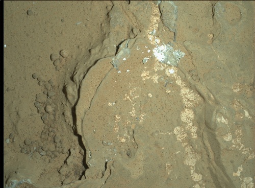
… and I was just going to say that it matched this sol 160 MAHLI thumbnail: ( update: click for large view, showing that the white material is not cleavage, but an exposed vein or layer. Cleavage of the dark material can be seen on the lower edge. )

… when some sol 159 Mastcam images came through including this one:

… so there it is! Then the question is where did it come from? It must have popped off the side of the large rock when it was toppled, and flipped over to this location, is all I can figure. I can only assume that the team will provide us with images of the main conflagration in due course.

Some theorizing: Referring to the tracks and the final placement of the rocks in the full scale “after” navcam image, above, it looks like the right front wheel rode up on the displaced rock as it turned right, backing toward the camera, along the line of rocks. It pushed the rock to the right with the edge of the wheel while trapping the vertical piece with downward pressure, popping it off to the side while driving the vertical piece back towards the camera, wedged against the adjacent rock. Note it is displaced that way, however it happened. To me, this shows that the rock was loose on the surface, and not anchored to anything deeper. ( It would be quite a puzzle for one edge of the rock to be anchored. ) The wheel rode up on the adjacent long rock, as you can see a white scrape along its ridge, moving towards the camera. It “touched down” briefly, then continued along the ridge to the position where the image was made. I’m thinking the other track was made “going in”, but I can’t account for the details. Of course the mission team knows all, but they are certainly less than effusive in the descriptions they give of these activities.

Update 3 : Shocker!
( Maybe I read too much Drudge 😉 )

It appears that this was a planned act. In the Jan 18, 2013 Curiosity Rover Update ( on Youtube, ) “Snake River” is not mentioned, even though it appears prominently in the opening shot, and Justin Maki states in narration that they plan to crush some rocks with the wheels on the way over to the drill site. I had started thinking that this may have been a purposeful maneuver because of the way it turned sharply and backed down the line of the lately named “Snake River”. I had thought of the despoilment factor a long time ago, but I’m still surprised they did this to a named monument, as it were, if indeed it was planned, as it surely seems to have been at this point.
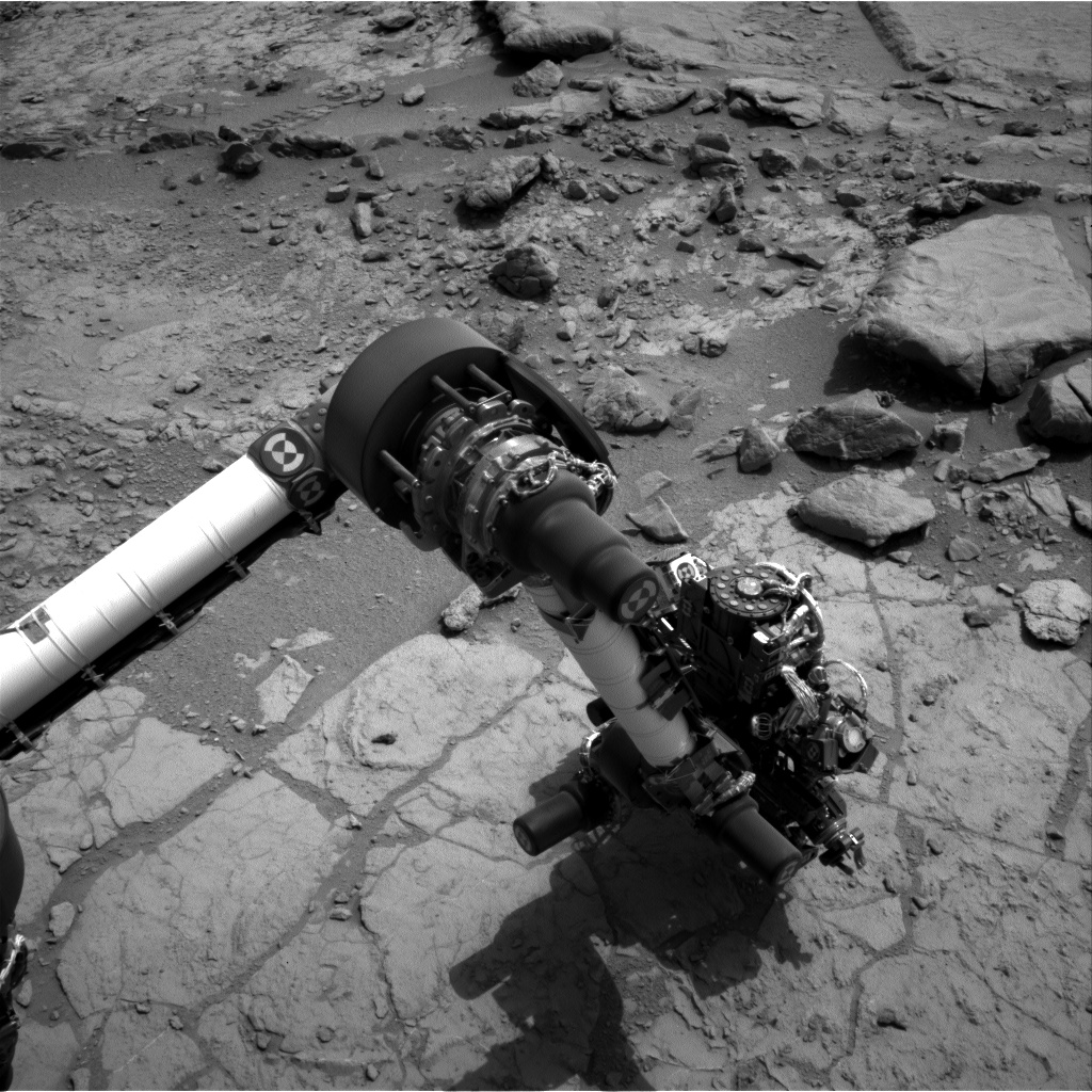
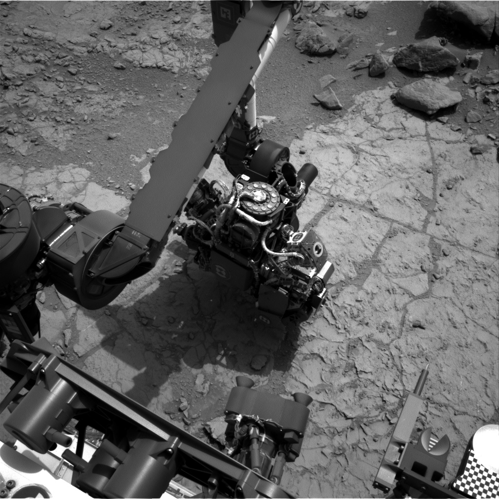
The John Klein drill site

NASA has announced the site of their first use of Curiosity’s drill, named “John Klein”, along with this press release image ( Click to enlarge – these are “hot links” ) :

They have other images of the panorama this is taken from, but here is my version made from the Sol 153 Mastcam raw image gallery. ( Click to enlarge … if you dare! 😉 )

The one thing they’re not saying, unless I missed it, is that this is really part of the Snake River site, and the Mastcam panorama was taken from the same site as the Navcam spherical panorama I published below. Here is a small ( 5 image ) cylindrical Navcam panorama from images taken from that site on Sol 152:

You can see the “lean-to” rock marking the John Klein site in the center mid-ground. To the left are the “head waters” of Snake River. To the right you can see “Mt. Fuji” on the horizon, which marks 10 degrees west of north from this area. At the bottom right corner you can see Curiosity’s tracks marking its path to Snake River.

These images can be combined with the previous Snake River panorama to form this grand conglomeration showing everything in one view:

Snake River

As widely broadcast, Curiosity just used its rotating brush to clean a spot near the “Snake River” site. Here is a spherical panorama of the site made from sol 151 Navcam images:
The front of curiosity is at the bottom left, where you can see the round sample tray, and below that, the drill bit holder. I presume the little flared cones are to receive the drill so it can grasp and withdraw a drill bit. I had to coax this image into the curved shape you see using the panorama editor in PTgui ( you just click and drag ) but the front and back wheels are still not parallel. They do turn, of course, but anyway if I tried to make them straight the scene became too distorted.

At the JPL Sol 150 Mastcam raw image page you can see a variety of images of the brushed spot. I believe the color images are made from Red, Green, and Blue filtered images, as opposed to using color sensors in the camera. We can infer that the spot, which is bright bluish white iin color, is dark in the raw red filtered B&W images, and bright in the blue images. Actually, in red it appears only slightly darker than the omnipresent red dust.

In the Navcam view, it is very hard to discern, even though it is fairly large, just in front of the sample tray. Compare this thumbnail ( linked from the MSL site ) to a ( clickable ) excerpt from the panorama I made, rotating it in paint.net to match the orientation:

Update: In the last two days Curiosity has moved forward a few feet, and the Navcam procided the images for this panorama on sol 153 :

Here you can see all three wheels on the right side, and the front “spoiler”, so the panorama is lined up pretty well. Note the right middle wheel is sitting right on top of the signature “Snake River” rock formation. All glory is fleeting. Just ahead of Curiosity, you can see a large rock at the left of the panorama, sort of a disk. It’s also visible in the sol 151 Navcam panorama above, and is featured in the following very nice sol 153 Mastcam panorama. When I made this one it came in at about 27 Meg, well above the 20 Meg upload limit. I was going to reduce it using Paint.net, but when I went to write it out I noticed it was saying 18 Meg at 100% resolution. Nevertheless, I reduced the “quality” to 70% and the size came down to 3 Meg, and it still looks good.

Update 2 : There are some sol 154 MAHLI images which are include closeups of locations within this panorama. Here is a “key” with one of the locations cicled in blue, along with an enlargement which has been rotated to match the MAHLI image orientation. ( Click it to see full resolution. )

Here is a panorama consisting of two MAHLI images spanning this location. Note how PTgui warped them to get a match. ( Click for full resolution. )

So, what is this stuff? Is it something of special interest? The JPL Curiosity site is still touting the brushmark as the latest thing. They are ostensibly looking for a place to try the drill, AFAIU, but maybe they are just sight-seeing. They also say Curiosity is about to head for Mt. Sharp, but they are still dawdling around in Yellowknife Bay.

A note on the appellation of “Snake River”: Between this and “Yellowknife Bay”, I’m wondering if we don’t have the influence of some outdoorsy type who has familiarity with these namesakes. I was thinking that the Martian Snake River was not the rocks per se, but the “canyon” which wends its way down to them. These rocks could be “The Pillars” on the Snake River, just below Evel Knievel’s jump site, as a matter of fact: