Sol 508 panoramorama

Here’s a key to several of the panoramas contained in the sol 508 Mast camera images, based on a sol 508 Navcam panorama ( click to enlarge. )

The individual Mastcam panorama’s follow below. Note the swirly moire effect in the overlay I did. This may be taken as a stamp of authenticity due to a slight relative rotation of the images. I just used resizing ( zoom in paint.net ) and “translation”, as it’s called in graphical terms.

The Mastcam panoramas are 7×2, 3×2, and 5×3, comprising 35 images in all. There is another closeup panorama which I plan to cover in another post.

This 7×2 panorama lies along the forward path of Curiosity. There’s been a lot of concern about the beating that Curiosity’s wheels are taking, and I’m thinking that they are doing some extra scouting to try to avoid the worst rocks.


This view shows the close horizon that has been in view for a month now. Note the large rock which has been visible as a “nub” for some time. Curiosity will soon pass it by.

This layered basin is another version of “Shaler” I guess, although this seems to be beautifully sculpted by Aeolus in the shape of a bowl. I think these features change on a time scale of thousands of years or more, and Curiosity is something of a bull in a china shop up there, but how else would we see it?

Sleuthing the MAHLI

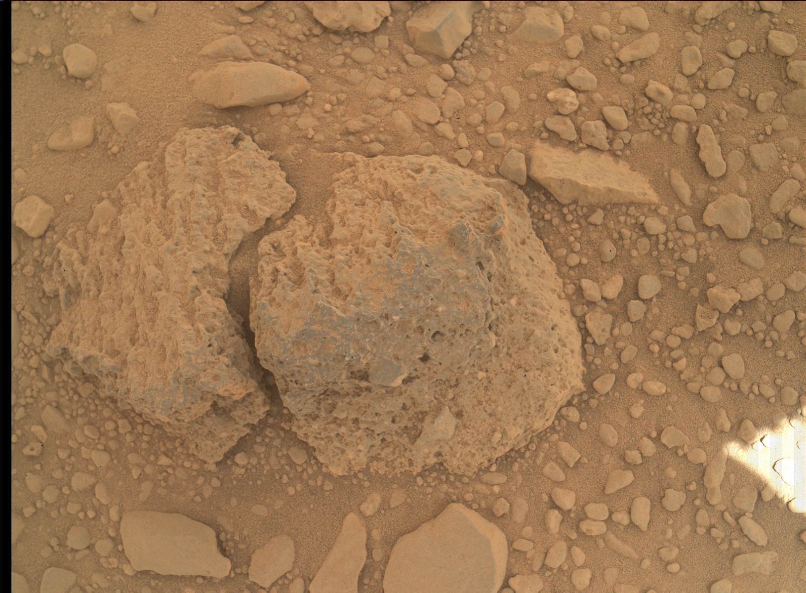
On Sol 506 Curiosity’s MAHLI acquired an image of a rock which had evidently attracted its, ah, curiosity.

But how so? The front Hazcam records this pair of images acquired at 2014-01-07 23:21:21 UTC and 2014-01-07 23:12:31 UTC, showing the deployment of the MAHLI above the imaged rock.

… but reminding ourselves that Curiosity’s brain resides at JPL, the action depicted must have been motivated by images previously acquired and transmitted, and we have to ask ourselves how this came about. In this case I think there’s a fair record.

We can discern that Curiosity arrived at this position on Sol 504, on which date we see a number of Navcam images of the area, including this double image “panorama” of the MAHLI image location


You can actually see the “MAHLI rock” to the left of the cylindrical joint projecting to the front, and the formation of darker rocks to the right of that are recognizable in the Front Hazcam images. These images were acquired around 2014-01-06 00:59, then around 2014-01-06 02:58, the Mastcam acquired the six images of this panoramic view


and there’s the rather nondescript “MAHLI rock” dead center.

This hardly explains what the particular attraction was, but it does give a record of the event if one is willing to “read between the images” … and I looked at a lot more of them!


Triangulating

Here’s another undercarriage view made with the MAHLI on Sol 476. I guess they’re still concerned about the wiring.

This time we have a nice front Hazcam shot of the MAHLI itself, pointed back at the front of Curiosity. It’s that little gizmo to the left of the “phone dial”, which is the APXS :

You’ll notice it’s an anaglyph! Most of the MSL raw image gallery is in stereo pairs, so I downloaded a free anaglyph maker ( anamk108 ) and it works well for me.

Curiosity has been dawdling near this spot for several sols, after making several good runs between sol 456 and sol 472. Here is a panoramic Mastcam view from sol 456, taken in the direction of travel. Note the small peak, or “rise” on the left, and the more distant “pass” or “canyon” appearing on the horizon to the right of center:

As Curiosity moved forward, the change in perspective on the rock patterns in front of the small peak were evident. Here is an attempt I made to triangulate between this sol 456 view and a later sol 465 NAVCAM view:


I wasn’t real sure about the foreground here, but I think the lines are about right.

Moving ahead to sol 470, we can see in this Mastcam panorama that Curiosity is much closer to the “canyon”, and it is not really a huge feature, but it does seem to be a little more spectacular than Yellowknife Bay.

I spent a lot of time staring at these rocks, but I couldn’t really line everything up. This is around when I decided to try the anaglyph idea. There is a lot of vertical relief in the form of a “rolling prairie” effect which is not evident in the raw images, since everything is littered with rocks. Here is a sol 470 Navcam anaglyph looking towards the “canyon”.

On sol 472, Curiosity was getting very close to this feature, and was adjacent to a large “sand pit” in front of it. In the foreground are several large rocks, which I felt I should be able to pick out in the sol 470 views, but I was having trouble doing this:

Of significant help was another anaglyph, from sol 472 this time, also showing these rocks in the foreground.

In the anaglyph, you can see that the large dark rock near the center is actually elevated a bit, and more to the foreground than it appears in the raw image. In the sol 470 anaglyph, it appears to be more even with the rock behind it, and this threw me off. These two rocks appear near the top left corner of the sol 470 anaglyph, and to the left of center in the far midground of the sol 470 Mastcam view, where they are fairly prominent.

When Curiosity moves past this “canyon”, I think it will be in new territory, and the changes in the landscape will continue as it finally approaches its “base camp” for the ascent of Mt. Sharp.

Sol 463 : A new view of Mount Fuji

This image was acquired with the MAHLI as it was evidently inspecting the undercarriage for possible clues to the floating bus voltage fluctuation. The composition is quite striking, and very suggestive of a human’s view peering under a vehicle, as I’m sure we’ve all done. It also makes for a novel “view of Mount Fuji”, in reference to one of my early posts, Six Views of Mount Fuji.

Sol 438 at Cooperstown

The Cooperstown structure seems similar to some of the ledges at Yellowknife Bay, but on a very limited scale. Curiosity took 10 Mastcam images comprising a circular panaorama around the base of the craft, and 5 Mastcam images comprising a short panoramic view of the Cooperstown structure.

The layered deposits in front of the ridge resemble Shaler, near Yellowknife Bay. The circular view of the base area contains a variety of rock types, including some at the right end of the arc ( near the wheel ) which have a similar texture to some rocks near Shaler, that I dubbed the “dead fish” in a previous post.

As these two composite images don’t overlap, their relationship isn’t evident at first examination. In fact, I was surprised that the 10 images formed a continuous arc after processing by PTGui, as I expected two tiers of 5 in a block.

However, there is a nice Navcam image that overlaps both of these:

… and I used Paint.net to form the following composite where the transparent Navcam view stitches the two panormas together. The overlap is surprisingly faithful, as this was done purely by hand using resizing and reorientation, but no stretching or skewing.

sol 426

During this several months trek of Curiosity, I have noted how difficult it is to track its progress by viewing the raw image gallery. It seems that the progress of a hundred meters or so completely changes the perspective of the near and mid ground, so that it’s difficult or impossible to place the future or past position of Curiosity in the images made on successive sols.

Nevertheless, it is always rewarding to review these images, and sol 426 presents some very interesting vistas, which do illustrate the problem I mention, since it seems that there was a displacement during that sol between two sessions of image taking.

First of all, there was a series of 22 images from the Mastcam which form a nearly 360 degree panorama encompassing a high resolution view of the “riverfront” as I think of the edge of the low lying dune fields fronting Mt. Sharp, since this is what its appearance suggests.

You can click on it, and it is not too unwieldy, since it is skinny. If you pan along it at full size, it’s just rocks, rocks, rocks! But that’s Mars. You can see a lot of detail, as Curiosity is much closer to the “river” than it was at Glenelg, and this is very exciting, if you’ve been following the mission.

These images were recorded around 2013-10-17 19:35:44 UTC, and make an interesting comparison to a lower resolution, or really lower magnification, Mastcam view made around 2013-10-17 23:24:38 UTC, so about 4 hours later, apparently after another short traverse. Here is that view.

If your anything like me, you’ll find it very difficult to correlate these two ( composite ) images, taken just hours apart. There is a link, though, in several NAVCAM images taken around the same time as the second, smaller, panorama. Here is a portion of one of them, truncated to emphasize its correlation with the panoramas.

Now here is an approximate overlay of that same NAVCAM image, further truncated, on top of the second panorama, which was reduced in scale to match ( at full size. )

Finally, here is a side by side comparison, again with the NAVCAM image at the same scale, with the high magnification panorama. I’ve marked some correspondences, as I see them, but note these are distorted by the displacement in position between the acquisition of the images. I would just comment that you would never spot this correspondence with a casual perusal, since you would naturally try to correlate the foregrounds of both images.

Well, there’s more where that came from! So … later.

On the road

The foothills of Mount Sharp have been a backdrop for Curiosity’s movements since it landed, and it’s movements in the first few months did not significantly change the perspective. Now with the traverse to the southwest towards a “base camp” for the ascent of Mount Sharp, we can see a shift in the view.

Here is a section of a recent sol 421 panorama compared with the corresponding portion of a sol 3 panorama made at the landing site. As I estimate them, the blue lines are radials from the landing site, and they appear as vertical lines in the sol 3 panorama, and the same for the green lines and the sol 421 panorama.

Here is the Hirise view of the location, which is the basis for some of the progress maps periodicially published on the MSL web page. I’ve drawn in an estimate of the lines of sight in the panoramas, as seen from above.


PHABULOUS!

Here’s an excerpt of a sol 351 Curiosity Mastcam image catching Phobos ( at bottom ) passing by Deimos high overhead in the wee hours, local time, 2013-08-01 08:44:11 UTC as labelled in the Raw Image Gallery. You can clearly see the features of Phobos, which make it very reminiscent of the Death Star.

I can recreate this event with my Starry Night software by setting my viewing coordinates to the Bradbury landing site on Mars. However, it doesn’t seem to quite match up in detail, and I can’t even come close to identifying the background stars. So that’s a bit of a mystery to me.

I haven’t seen any publicity for this yet on the Mars Science Laboratory web site, but I guess they’ll get around to it. There was publicity for a series of Navcam photos from Sol 317 made into a movie, but that was at low resolution.

sol 347

Here is a circular panorama made from the sol 347 Right Navcam raw image gallery. The ( relatively ) rapid progress during the last 10 sols or so have afforded  some interesting views, but the most interesting thing is the overall progress itself. Even though it has been just a few hundred meters, there have been a number of new landmarks in the form of rock piles. On each sol we can see the track of Curiosity trailing off to the east in the direction of “Fort Apache”, as evidenced in this image near three o’clock. Mt. Sharp is all along the bottom edge, and “Mt. Fuji” is near one o’clock.

Here is the upper left quadrant as a cylindrical panorama composed of 6 Navcam images. It gives a view of the “rock piles” which dot the area, and of which “Rocknest” was a much smaller example. There were several piles near Rocknest similar to it. My own blue sky theory is that these represent secondary impact events. … It’s gotta be something!

Farewell to all that

As Curiosity “head’s out of town” on Sol 329, it captured the six images in this spherical panorama with its Right Navcam. ( Click to enlarge. ) I’ve labeled a few of the landmarks ( including some I named in previous posts. ) You may note that it seems to be heading away from Mount Sharp, which is its destination. It is going back the way it came, and I think the idea is to traverse the high ground near the landing site, rather than risk getting bogged down in the dunes along the base of the mountain.