Sleuthing Chelyabinsk

Like many others, I was astounded not only by the Chelyabinsk meteor fall itself, but by the seemingly  outlandish estimates of the power of the “explosion” which was presumed to have caused the damage on the ground. I believe they’re saying 500 kilotons now. At one point I was ready to give in and go along, but in perusing the extensive Youtube material and other references, I saw others voicing many of the same points that I had thought of, for example that “there was no explosion” ( ! ) How can you say there was no explosion ! Well, because the brilliant flash lasting for several seconds traveled through the air for some miles during that time, then blinked out. What was left was a smoke trail. Then, a LONG time later, as much as two minutes it seems, there was a huge but very sharp crack that did the damage, followed by a series of much less intense bangs and pops that sounded like gunfire. It certainly seems that all of these were “sonic booms”.

Well, enough generalities. Let’s just look at a simple analysis of the “traffic camera” video. Here’s a composite of three frames with some lines drawn on it:
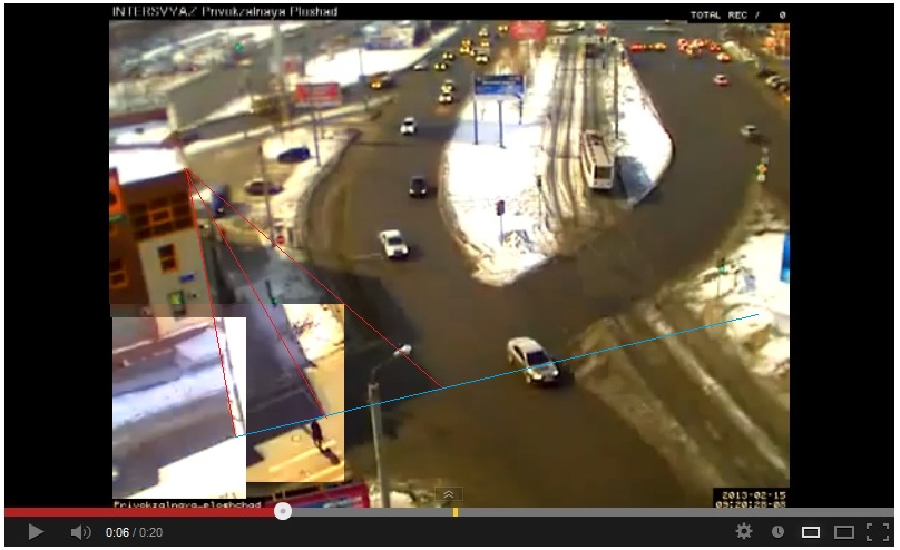
The red lines are drawn from the corner of the building to its shadow at three different times, with the lapse of 2.0 seconds, and 1.0 seconds between them. The two later shadows were pasted on to the original scene. Then the blue line connecting them gives a record of the track of the meteor flash in the sky. The corner of the building has ( lat, long ) = ( 55.143470, 61.414289 ), incidentally. That was some sleuthing right there! The view is slightly to the east of due south.

Now concentrating on the last interval of one second, we see that this is near the closest approach of the meteor to this location, and eschewing trigonometry, we can estimate that the red sides of the triangle formed by the line of sight forming the shadow track, are to the blue baseline of the track, as 8 to 3. We simply note that we are looking more or less face on to the triangle from the vantage of the camera and estimate from the image.

The point is that the distance of the meteor from the location is in the same 8 to 3 ratio to the distance it flew during that one second. Suppose it was moving at Mach 10, then it flew about 2 miles in that time, and the distance is then 16/3 miles, or say 6 miles … not very far away! We may suppose about 4 miles high and 4 miles along the ground.

I had first noticed that the elevation above the horizon changed considerably among the videos that seemed to be taken around the Chelyabinsk area. ( There is one stated to be from Magnitogorsk, which is 150 miles away. The angle of view looks right, but 4 miles only gives you about 1.5 degrees above the horizon. It was very low, actually, so I’m sticking with my estimates for now. )

In several videos people are standing around gawking at the smoke trail when the big bang comes. I saw a comment saying that the bang was produced earlier and this is why it arrived so late, as the meteor outran it over a long distance. I had started thinking that myself when I decided that the smoke trail couldn’t be 20 miles high, and 500 kilotons just does not compute!

Anyway, I think the shadow videos ( there’s another of the Chelyabinsk city square ) are very robust evidence.


Update:

I sleuthed the location of the Magnitogorsk video, which enabled me to get a triangulation on the meteor path based on local landmarks. The red lines on the Google Maps screen shot are my estimates of the lines of sight to the first appearance ( on the right ) and the flareup from the site. Being at right angles to the Chelyabinsk lines of sight estimated from the shadow video, I think it gives a pretty good location, although far from exact. It’s much further south of Chelyabinsk than I had been thinking, which means it’s a lot higher ( ahem ). The yellow line is a line of sight to the flareup from Kamensk-Uralsky, about 100 miles north of Chelyabinsk. The dark blue line is parallel to the ground track of the shadow in Chelyabinsk, and the light blue line is an attempt to account for the tilt of the trajectory, which means it must be displaced that way, but maybe not that much.
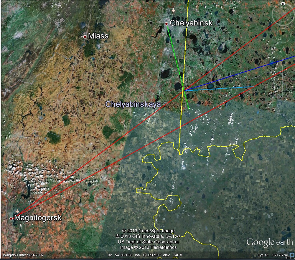
BTW, putting the track to the south this way makes a discrepancy with its placement in the weather satellite photo, so that’s another problem. One must have patience.

Update 2:

Here’s a Colorado State University montage incorporating an annotated version of the extant weather satellite image of the Chelyabinsk Meteor plume ( btw, that’s “che YAH binsk”, as I hear it in Russian reportage ) :
… and here’s an overlay of my marked up Google Earth image from above, aligned using the dark spots which appear near “Chelya..” as above:
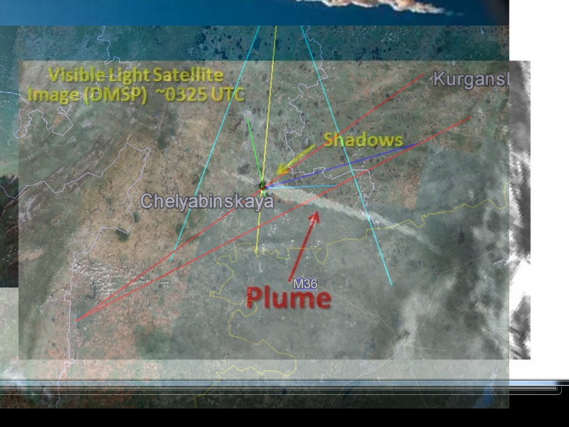
The “dark spots” line up very well, so the overlay seems accurate. Note the excellent agreement of my line-of-sight location of the “flash” with the “plume turrets” identified by CSU. Note also my UNDERestimation of the effect of the inclination on the estimation of the ground track based on the shadow track. The extra light blue lines radiating from Kamensk-Uralsky are my estimate of the extent of the visible smoke trail in the seconds after the flash. This includes a significant length to the west of the flash, as shown also in the CSU montage.

So, I guess I should be happy now, but I still can’t bring myself around to 500 kilotons!
The 15 minute miss

Bill Nye the Science Guy gave the figure of 15 minutes for the amount of time by which the earth will miss a collision with asteroid DA14 at closest approach a few hours from now. What does this mean? I believe the idea is that the orbits of the earth and the asteroid intersect, and that the difference in the time of a passage through the point of intersection is 15 minutes. We can derive the 15 minute figure by taking 2pi times 93 million miles and dividing by 4 * 24 * 365.25, which gives the distance the earth moves along its orbit in 15 minutes, in the traditional approximation, that is. This comes to 16664.848 miles, near enough to the 17240 miles of the official close approach distance to justify the logic of this assumption. But is the premise of this idea correct?

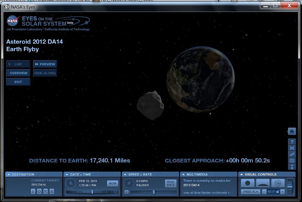
Not really! Here is a screen shot from a downloaded version of JPL’s Eyes on the Solar System, the basis for a video that’s also available on the internet:
If you download the player, as I did, and feel your way through the controls and options, you will see that you get a lot of extras over the video. Notably, the player renders the night side of earth, which is not in the video for some reason. Note in the screen shot that Mars, Mercury and Uranus are all visible ( at about 2 o’clock of the earth’s disk for Mars and Mercury, and 5:30 for Uranus. )

The point is that DA14 is just opposite the sun at closest approach, so it appears that the timing was near perfect for a collision, but the orbits do not in fact intersect, with DA14 passing “spaceside” in the plane of the ecliptic.

You can see that the principal motion of DA14 relative to the earth is from below the plane of the ecliptic to above it, and nearly perpendicular. In fact, the earth is overtaking and passing DA14 along the line of its orbit, as can be seen in the NEO Orbit applet for DA14, even though the approach is too close to be seen in detail on the available scale.

The period of DA14 is 314 days, but its semimajor axis is .91 AU, or 91% that of earth’s orbit. Since it is near the peak of its arc, so to speak, it is analogous to a suborbital missile at its apogee being overtaken by an orbiting satellite at the same altitude.

Well, we avoided a collision, but we still got hit by an astronomy lesson.

The Mare’s Nest

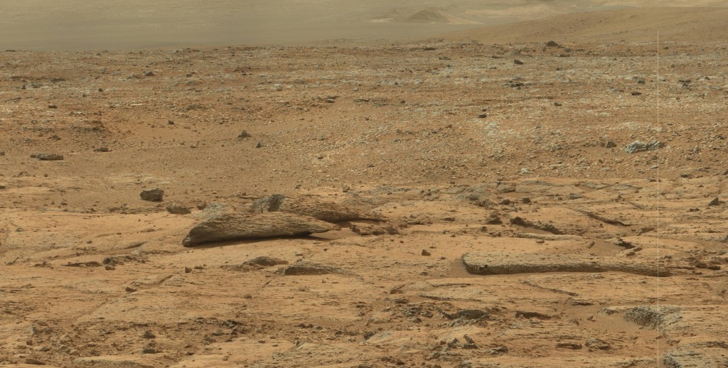
Here’s an excerpt from a very large panorama made from 135 sol 184 Mastcam images. It’s missing 5 images as “holes” in its proper 7X20 array, and sometimes these show up later in the image gallery, so I’ll hold off on posting that, and just show this excerpt: ( click to enlarge )

The panorama is a rather uninteresting vista, except for its sheer scope, of the western end of Yellowknife Bay from the vantage of the Drill Site. But the detail does show off this interesting structure that I’m calling the Mare’s Nest, which seems to be similar to the “seashells” of my previous post. Surely it’s a real question how these structures formed, and from the name I’ll give myself license to speculate a little bit.

It suggests to me that the ground was shattered by an impact, possibly a secondary impact of a boulder flung from some meteorite fall. I suppose that these must have been quite common over the aeons. On the moon, the well tilled surface is the result of this kind of “gardening” as it is called, and the entire surface is a rubble heap. On Mars, we might suppose that while more orderly processes have given  the surface a stratified structure, impacts have still left their mark, and remain in place for millions of years. … So there you are, a mare’s nest!

A Plethora of Panoramas

I’ve featured a number of panoramas made from mastcam and navcam images, and of course JPL occasionally features some as well, but the raw image gallery contains many more, in content, needing only assembly with PTgui or another panorama maker. I’ve accumulated many that I have not shown and here are a few of them.

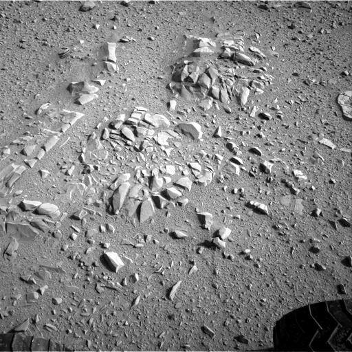
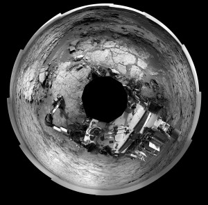
I only recently formed this circular panorama from sol 52 navcam images. It was a unique opportunity as the navcam images don’t usually present such a comprehensive view. This view was at the “shell” site where the light balance gives the appearance of seashells to the very interesting arrangement of rocks near the “feet” of Curiosity. Here I use one of the component images, reduced by 50%, as a link to the panorama, instead of a “thumbnail”.

The “shells” of the posted image are at the immediate lower right of center, and rotated in orientation, but easily recognizable. At the top in the middle ground is “rocknest” where Curiosity took its first “scoops”. Above it is “flattop” and to the left along the top edge is “Fort Apache”, ( using my own nomenclature. ) Just above rocknest to the right are two “jetties” which I have found hard to identify in views from other angles. Near one o’clock in the far middle ground are the “dead fish” which I featured earlier. At about two o’clock is “shaler”. After visiting rocknest and shaler, Curiosity traversed counter clockwise in this view, entering Yellowknife Bay and traversing up to its northern boundary, visible at about eleven o’clock as a low wall with a dark shadow. After exploring there it traversed toward the center of this view to its current location in the near middle ground, largely hidden by the higher ground in front of it. At 7 o’clock you can see the tracks Curiosity left as it came over the ridge which separates the landing site from most of the exploration to date, so this panorama stands as a sort of Rosetta stone of this first phase of the mission.

Having mentioned the “dead fish”, here is the full panorama, linked from the same excerpted image previously posted:

It’s still big, but with improved skills and the miracle of jpeg, I was able to reduce its storage size without sacrificing size or quality. I think the square shape makes it one of Curiosity’s most elegant productions.

Now referring to the current location at the John Klein drill site, here are two panoramic views from sol 125 and sol 172 which make an interesting comparison. I’m taking the latter first, at the current location on the site, and again using excerpts to link them.

The excerpt is visible along the “garden wall” to the right of Curiosity’s “water tank”, as I always think of it. ( It’s actually the UHF antenna! ) The view is toward the rear of Curiosity, back along the north wall of the bay, along which it traversed. The excerpted view in the post has been reduced to 40% of its size in the panorama, but is still much larger than the corresponding excerpt from the view made at a greater distance, out in the middle of the bay:

Note that this is a much smaller image, composed of 1 X 7 mastcam images, as opposed to 4 X 20 – 4 components of the sol 172 panorama. It’s a great view nevertheless. You can see the John Klein site at the left as sort of a “harbor” at the end of the bay, and you can see the “lean-to” featured in earlier posts just visible along the raised front edge of the harbor. I have found that comparison of these two views provides endless challenges of perspective. Enjoy!

Update: Here’s a sol 168 navcam panorama at the John Klein site. It’s notable for its symmetric composition around the center, and for the appearance of the “robotic arm” feature right at the 12 o’clock position. This feature was “discovered” in the sol 173 mastcam images, as reported  elsewhere. Here, it doesn’t look like much, but it is definitely identifiable.

Also notable is the site of one of Curiosity’s “crushing” maneuvers, close in near 3 o’clock. It appears in color in this sol 183 thumbnail view: