The Mare’s Nest

Here’s an excerpt from a very large panorama made from 135 sol 184 Mastcam images. It’s missing 5 images as “holes” in its proper 7X20 array, and sometimes these show up later in the image gallery, so I’ll hold off on posting that, and just show this excerpt: ( click to enlarge )

The panorama is a rather uninteresting vista, except for its sheer scope, of the western end of Yellowknife Bay from the vantage of the Drill Site. But the detail does show off this interesting structure that I’m calling the Mare’s Nest, which seems to be similar to the “seashells” of my previous post. Surely it’s a real question how these structures formed, and from the name I’ll give myself license to speculate a little bit.

It suggests to me that the ground was shattered by an impact, possibly a secondary impact of a boulder flung from some meteorite fall. I suppose that these must have been quite common over the aeons. On the moon, the well tilled surface is the result of this kind of “gardening” as it is called, and the entire surface is a rubble heap. On Mars, we might suppose that while more orderly processes have given  the surface a stratified structure, impacts have still left their mark, and remain in place for millions of years. … So there you are, a mare’s nest!

A Plethora of Panoramas

I’ve featured a number of panoramas made from mastcam and navcam images, and of course JPL occasionally features some as well, but the raw image gallery contains many more, in content, needing only assembly with PTgui or another panorama maker. I’ve accumulated many that I have not shown and here are a few of them.

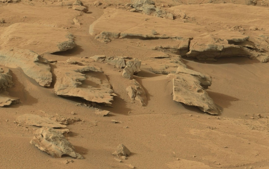
I only recently formed this circular panorama from sol 52 navcam images. It was a unique opportunity as the navcam images don’t usually present such a comprehensive view. This view was at the “shell” site where the light balance gives the appearance of seashells to the very interesting arrangement of rocks near the “feet” of Curiosity. Here I use one of the component images, reduced by 50%, as a link to the panorama, instead of a “thumbnail”.

The “shells” of the posted image are at the immediate lower right of center, and rotated in orientation, but easily recognizable. At the top in the middle ground is “rocknest” where Curiosity took its first “scoops”. Above it is “flattop” and to the left along the top edge is “Fort Apache”, ( using my own nomenclature. ) Just above rocknest to the right are two “jetties” which I have found hard to identify in views from other angles. Near one o’clock in the far middle ground are the “dead fish” which I featured earlier. At about two o’clock is “shaler”. After visiting rocknest and shaler, Curiosity traversed counter clockwise in this view, entering Yellowknife Bay and traversing up to its northern boundary, visible at about eleven o’clock as a low wall with a dark shadow. After exploring there it traversed toward the center of this view to its current location in the near middle ground, largely hidden by the higher ground in front of it. At 7 o’clock you can see the tracks Curiosity left as it came over the ridge which separates the landing site from most of the exploration to date, so this panorama stands as a sort of Rosetta stone of this first phase of the mission.

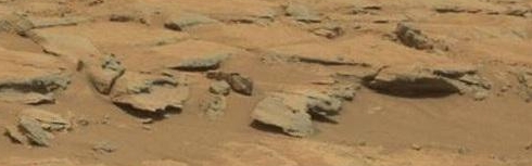
Having mentioned the “dead fish”, here is the full panorama, linked from the same excerpted image previously posted:

It’s still big, but with improved skills and the miracle of jpeg, I was able to reduce its storage size without sacrificing size or quality. I think the square shape makes it one of Curiosity’s most elegant productions.

Now referring to the current location at the John Klein drill site, here are two panoramic views from sol 125 and sol 172 which make an interesting comparison. I’m taking the latter first, at the current location on the site, and again using excerpts to link them.

The excerpt is visible along the “garden wall” to the right of Curiosity’s “water tank”, as I always think of it. ( It’s actually the UHF antenna! ) The view is toward the rear of Curiosity, back along the north wall of the bay, along which it traversed. The excerpted view in the post has been reduced to 40% of its size in the panorama, but is still much larger than the corresponding excerpt from the view made at a greater distance, out in the middle of the bay:

Note that this is a much smaller image, composed of 1 X 7 mastcam images, as opposed to 4 X 20 – 4 components of the sol 172 panorama. It’s a great view nevertheless. You can see the John Klein site at the left as sort of a “harbor” at the end of the bay, and you can see the “lean-to” featured in earlier posts just visible along the raised front edge of the harbor. I have found that comparison of these two views provides endless challenges of perspective. Enjoy!

Update: Here’s a sol 168 navcam panorama at the John Klein site. It’s notable for its symmetric composition around the center, and for the appearance of the “robotic arm” feature right at the 12 o’clock position. This feature was “discovered” in the sol 173 mastcam images, as reported  elsewhere. Here, it doesn’t look like much, but it is definitely identifiable.

Also notable is the site of one of Curiosity’s “crushing” maneuvers, close in near 3 o’clock. It appears in color in this sol 183 thumbnail view:

Where’s Waldo ?

Actually, I play this game a lot in the Curiosity Raw Image Gallery, trying to place various images in a larger context. This one was epic. The sol 165 MAHLI gallery contains some artificially lit images, taken at night, of this ( hot linked ) feature:
The scale can be judged only subjectively, and the location “could be anywhere”. I tracked the recent movements of Curiosity and had an idea around where it must have been. Never would have found it though if it hadn’t been for two things: This sol 166 image of the same feature at a slightly smaller scale ( again hot linked ) :


… and this “smoking gun” image from the front hazcam with  virtually the same time stamp ( you guessed it ) :
Note from the closeups the evidence of Curiosity’s wheel-crush maneuver. The following sol 164 Front Hazcam image shows the left front wheel sitting right on the spot:
This is right in front of the “lean-to” formation which identifies the John Klein drilling site. It so happens that a nice 6 image panoramic view of the spot from sol 162 gives good detail, so that the formation can be seen in a wide context: ( click to enlarge! )

Do you see it? I found it still very difficult to spot even though the location is narrowly defined. For one thing, that light vein is hard to see, and … it’s upside down! So here’s a comparison where I rotated and foreshortened the closeup to compare with an excerpt from the panorama, and there’s Waldo!

Oops!

I commented in my Snake River post that Curiosity was sitting right on top of the signature rock formation, but now they’ve gone and done it. From these before and after Navcam images you can see that Curiosity backed over it and knocked over, or broke off, a prominent piece.
The description of the formation in the 01.04.2013 Status Report says that it “transects” the flat rocks that form the level surface, and the way I read it, thay are saying that they are actually jutting up through them.


Seeing the way it is dislodged, though, it looks like it was just sitting there. If it broke off, I can’t discern the base where it was attached. Well, just a lot of questions, and I hope they at least get some more images of this situation with the Mastcam.


Update: Aha!

The breakage is on the side of the rock! The image below shows the corresponding parts of the whole and separated rock. Very Curious!

Update 2 : More from the scene of the crime:

I had just finished doing this crude comparison of b/a in the lower left corner, showing the appearance of a new rock, circled in red:

… and I was just going to say that it matched this sol 160 MAHLI thumbnail: ( update: click for large view, showing that the white material is not cleavage, but an exposed vein or layer. Cleavage of the dark material can be seen on the lower edge. )

… when some sol 159 Mastcam images came through including this one:

… so there it is! Then the question is where did it come from? It must have popped off the side of the large rock when it was toppled, and flipped over to this location, is all I can figure. I can only assume that the team will provide us with images of the main conflagration in due course.

Some theorizing: Referring to the tracks and the final placement of the rocks in the full scale “after” navcam image, above, it looks like the right front wheel rode up on the displaced rock as it turned right, backing toward the camera, along the line of rocks. It pushed the rock to the right with the edge of the wheel while trapping the vertical piece with downward pressure, popping it off to the side while driving the vertical piece back towards the camera, wedged against the adjacent rock. Note it is displaced that way, however it happened. To me, this shows that the rock was loose on the surface, and not anchored to anything deeper. ( It would be quite a puzzle for one edge of the rock to be anchored. ) The wheel rode up on the adjacent long rock, as you can see a white scrape along its ridge, moving towards the camera. It “touched down” briefly, then continued along the ridge to the position where the image was made. I’m thinking the other track was made “going in”, but I can’t account for the details. Of course the mission team knows all, but they are certainly less than effusive in the descriptions they give of these activities.

Update 3 : Shocker!
( Maybe I read too much Drudge 😉 )

It appears that this was a planned act. In the Jan 18, 2013 Curiosity Rover Update ( on Youtube, ) “Snake River” is not mentioned, even though it appears prominently in the opening shot, and Justin Maki states in narration that they plan to crush some rocks with the wheels on the way over to the drill site. I had started thinking that this may have been a purposeful maneuver because of the way it turned sharply and backed down the line of the lately named “Snake River”. I had thought of the despoilment factor a long time ago, but I’m still surprised they did this to a named monument, as it were, if indeed it was planned, as it surely seems to have been at this point.

The John Klein drill site

NASA has announced the site of their first use of Curiosity’s drill, named “John Klein”, along with this press release image ( Click to enlarge – these are “hot links” ) :

They have other images of the panorama this is taken from, but here is my version made from the Sol 153 Mastcam raw image gallery. ( Click to enlarge … if you dare! 😉 )

The one thing they’re not saying, unless I missed it, is that this is really part of the Snake River site, and the Mastcam panorama was taken from the same site as the Navcam spherical panorama I published below. Here is a small ( 5 image ) cylindrical Navcam panorama from images taken from that site on Sol 152:

You can see the “lean-to” rock marking the John Klein site in the center mid-ground. To the left are the “head waters” of Snake River. To the right you can see “Mt. Fuji” on the horizon, which marks 10 degrees west of north from this area. At the bottom right corner you can see Curiosity’s tracks marking its path to Snake River.

These images can be combined with the previous Snake River panorama to form this grand conglomeration showing everything in one view:

Snake River

As widely broadcast, Curiosity just used its rotating brush to clean a spot near the “Snake River” site. Here is a spherical panorama of the site made from sol 151 Navcam images:
The front of curiosity is at the bottom left, where you can see the round sample tray, and below that, the drill bit holder. I presume the little flared cones are to receive the drill so it can grasp and withdraw a drill bit. I had to coax this image into the curved shape you see using the panorama editor in PTgui ( you just click and drag ) but the front and back wheels are still not parallel. They do turn, of course, but anyway if I tried to make them straight the scene became too distorted.

At the JPL Sol 150 Mastcam raw image page you can see a variety of images of the brushed spot. I believe the color images are made from Red, Green, and Blue filtered images, as opposed to using color sensors in the camera. We can infer that the spot, which is bright bluish white iin color, is dark in the raw red filtered B&W images, and bright in the blue images. Actually, in red it appears only slightly darker than the omnipresent red dust.

In the Navcam view, it is very hard to discern, even though it is fairly large, just in front of the sample tray. Compare this thumbnail ( linked from the MSL site ) to a ( clickable ) excerpt from the panorama I made, rotating it in paint.net to match the orientation:

Update: In the last two days Curiosity has moved forward a few feet, and the Navcam procided the images for this panorama on sol 153 :

Here you can see all three wheels on the right side, and the front “spoiler”, so the panorama is lined up pretty well. Note the right middle wheel is sitting right on top of the signature “Snake River” rock formation. All glory is fleeting. Just ahead of Curiosity, you can see a large rock at the left of the panorama, sort of a disk. It’s also visible in the sol 151 Navcam panorama above, and is featured in the following very nice sol 153 Mastcam panorama. When I made this one it came in at about 27 Meg, well above the 20 Meg upload limit. I was going to reduce it using Paint.net, but when I went to write it out I noticed it was saying 18 Meg at 100% resolution. Nevertheless, I reduced the “quality” to 70% and the size came down to 3 Meg, and it still looks good.

Update 2 : There are some sol 154 MAHLI images which are include closeups of locations within this panorama. Here is a “key” with one of the locations cicled in blue, along with an enlargement which has been rotated to match the MAHLI image orientation. ( Click it to see full resolution. )

Here is a panorama consisting of two MAHLI images spanning this location. Note how PTgui warped them to get a match. ( Click for full resolution. )

So, what is this stuff? Is it something of special interest? The JPL Curiosity site is still touting the brushmark as the latest thing. They are ostensibly looking for a place to try the drill, AFAIU, but maybe they are just sight-seeing. They also say Curiosity is about to head for Mt. Sharp, but they are still dawdling around in Yellowknife Bay.

A note on the appellation of “Snake River”: Between this and “Yellowknife Bay”, I’m wondering if we don’t have the influence of some outdoorsy type who has familiarity with these namesakes. I was thinking that the Martian Snake River was not the rocks per se, but the “canyon” which wends its way down to them. These rocks could be “The Pillars” on the Snake River, just below Evel Knievel’s jump site, as a matter of fact:

Flattop

“Flattop” is a prominent feature visible in a number of Navcam images, and captured in detail in this excerpt from a panorama made from sol 107 Mastcam images.

To the left you can see a low peak I think of as “Fort Apache”. It is situated at the northeastern end of the front of Mt. Sharp, and I can imagine it as an outpost on the lookout for marauding Tharks.  It is marked in blue in my North Rim Redux post.

Anyway, the relative position of Flattop and Fort Apache changes noticeably as Curiosity shifts position by a few tens of meters so Flattop’s position can be triangulated against the more distant Fort Apache.

JPL published a map of Curiosity’s recent movements, shown here:


Flattop is not visible as it is just off the map to the east. However, this map is taken from an available Hirise view ( with contrast enhancement, ) and I show an excerpt from the original below with the position of Flattop indicated, as I discern it, and Curiosity’s position at sol 107 marked with a star. ( Click to enlarge ! )

The “Dead Fish”

This striking pair of rocks reminded me of “beached whales” on first glance, but I think they do look more like fish.  ( And doesn’t that look like a dinosaur bone to the right, there? ) They are prominent in a beautiful 37 Meg panorama formed from a 6×6 array of 36 mastcam images from Sol 109. Too big to upload. This 3 Meg “detail” is really what I was interested in, anyway. I included enough to show some foreground and “Ellis Island” in the background ( which defines the direction of the view. )

How big are they? they seem to be in the 6-10 foot range, to me. Dunno. They are visible in a few of the Navcam views, but I’ll leave that as an exercise for now.

Curiosity must have been interested to devote all this bandwidth to it. It’s kind of an “off” view, looking far to the right of  “Yellowknife Bay”, where Curiosity was headed at this point. These rocks are typical of a number of formations in the area, even including the cross sectional cleavage. I think the “scaly” texture is the layering so predominant at Gale, and the cleavage occurs when these sculpted outcroppings get undercut and can no longer support their own weight. Imagine sitting there watching one of these develop for thousands upon thousands upon thousands of years! ( That covers a million, right ? )

Update: Here are three views of the “dead fish” formation taken from Navcam panoramas for the labeled sol dates. The sol 100 images were taken at a shorter focal length, accounting for the smaller appearance. It was actually about the same distance from Curiosity as on sol 103. ( I can tell right away because PTgui makes crazy looking spiky squares for these short focal length images. )

The view directions are roughly SE, SSE, and NE, in that succession. On sol 120, Curiosity was at “shaler”, which is visible in the foreground ( and also on the right side of the sol 100 view.)  You can see that the dead fish are just to the NE of shaler. I’m frustrated and puzzled that Curiosity didn’t get more Mastcam shots of them, especially since it went right by them on the way over to Yellowknife Bay, visible in the sol 120 view behind the dead fish.

Using the sol 103 view, I was able to calibrate the angular scale of the photo and determine that the frontmost “fish” subtended about 0.068 radians. Using the JPL track map, I estimated the distance at 30 meters, giving 2.0 meters as its length.


North Rim Redux

( Click the posted images to see them full size. )

I had been looking for the proper scale of image to show the north rim of Gale Crater in the same view with the Curiosity landing site, yet detailed enough to identify features along the rim.

The magic word was “context”. The Mars Reconnaissance Orbiter has a “context camera” whose images are at a much smaller scale than the Hirise images, which show local ground detail. I found this at a german-language site, www.raumfahrer.net ( that’s “space traveller” . )

The image is credited there to NASA/JPL, and is composed of a number of context images. I have excerpted it to show the north rim, and of course highlighted several features to match them to the previously posted panorama.

The red highlight is “Mount Fuji”, as I dubbed it, in the previous post.